


Compass Pro (Altitude, Speed Location, Weather)

Deskripsi Compass Pro (Altitude, Speed Location, Weather)
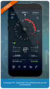
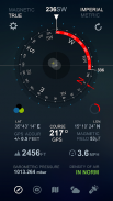
Compass Pro is the app for professionals as well as amateurs! Compass Pro is a real compass! It shows device real-time orientation to magnetic fields. It's displays lot of useful information like location, altitude, speed, magnetic field, barometric pressure, etc.
Compass Pro is easy to use. Following a particular bearing is easier too. Just tap on button to set a particular bearing and the app will then draw a red arc around the inside of the compass circle to indicate how far you’re deviating from your set course.
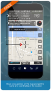
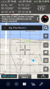
Compass pro has a map with lot of functionalities. Different map types, SMS your location, search any place, move cross pointer on the map and get the name and coordinates of the location.
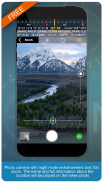
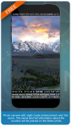
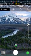
Photo camera with night mode enhancement and zoom. The name and full information about the location will be placed on the taken photo.
Coordinates are shown in next formats:
- Dec Degs (DD.dddddd˚)
- Dec Degs Micro (DD.dddddd "N, S, E, W")
- Dec Mins (DDMM.mmmm)
- Deg Min Secs (DD°MM'SS.sss")
- Dec Mins Secs (DDMMSS.sss")
- UTM (Universal Transverse Mercator)
- MGRS (Military Grid Reference System)
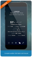
Complete weather information and forecast.
1. Compass
--- Shows device real-time orientation to magnetic fields.
--- Ability to switch between true and magnetic North.
--- Particular bearing
--- Location coordinates (longitude, latitude).
--- Course
--- Speed
--- Altitude
--- Ability to switch between mph, feet units and kmh, meter units.
2. Camera
--- Location Stamp photos
--- Zoom
--- Light Amplifier
--- Flashlight
3. Map
--- Current date and time.
--- Current GMT time.
--- Standard, satellite, hybrid, terrain maps.
--- Current location.
--- Location search.
--- Location name.
--- SMS location
4. Weather
--- Temperature information.
--- Humidity
--- Pressure
--- Ability to switch between Celsius and Fahrenheit.
Kompas Pro adalah aplikasi untuk para profesional maupun amatir! Kompas Pro adalah kompas nyata! Ini menunjukkan perangkat real-time orientasi ke medan magnet. Ini menampilkan banyak informasi berguna seperti lokasi, ketinggian, kecepatan, medan magnet, tekanan barometrik, dll.
Kompas Pro mudah digunakan. Mengikuti bantalan tertentu juga lebih mudah. Cukup ketuk tombol untuk mengatur bantalan tertentu dan aplikasi kemudian akan menggambar busur merah di sekitar bagian dalam lingkaran kompas untuk menunjukkan seberapa jauh Anda menyimpang dari jalur yang Anda tentukan.
Kompas pro memiliki peta dengan banyak fungsi. Jenis peta yang berbeda, SMS lokasi Anda, cari tempat mana pun, gerakkan penunjuk silang pada peta dan dapatkan nama dan koordinat lokasi.
Kamera foto dengan peningkatan mode malam dan zoom. Nama dan informasi lengkap tentang lokasi akan ditempatkan pada foto yang diambil.
Koordinat ditampilkan dalam format berikutnya:
- Dec Degs (DD.ddddd˚)
- Dec Degs Micro (DD.dddddd "N, S, E, W")
- Des Mins (DDMM.mmmm)
- Deg Min Dtk (DD ° MM'SS.sss ")
- Dec Mins Secs (DDMMSS.sss ")
- UTM (Universal Transverse Mercator)
- MGRS (Sistem Referensi Grid Militer)
Informasi dan ramalan cuaca lengkap.
1. Kompas
--- Menunjukkan orientasi waktu-nyata perangkat ke medan magnet.
--- Kemampuan untuk beralih antara Utara benar dan magnet.
--- Bantalan khusus
--- Koordinat lokasi (bujur, lintang).
--- Tentu saja
--- Kecepatan
--- Ketinggian
--- Kemampuan untuk beralih antara satuan mph, satuan kaki dan kmh, meter.
2. Kamera
--- Foto Lokasi Cap
--- Zoom
--- Penguat Cahaya
--- Senter
3. Peta
--- Tanggal dan waktu saat ini.
--- Waktu GMT saat ini.
--- Peta standar, satelit, hibrid, medan.
--- Lokasi saat ini.
--- Pencarian lokasi.
--- Nama lokasi.
--- Lokasi SMS
4. Cuaca
--- Informasi suhu.
--- Kelembaban
--- Tekanan
--- Kemampuan untuk beralih antara Celsius dan Fahrenheit.
Compass Pro (Altitude, Speed Location, Weather) - Versi 2.3
(28-02-2020)
Compass Pro (Altitude, Speed Location, Weather) - Informasi APK
Versi APK: 2.3Paket: com.dragon.compassproVersi Terakhir dari Compass Pro (Altitude, Speed Location, Weather)
Versi lain


 3.79
3.79


Aplikasi pada kategori yang sama


Anda juga mungkin suka...
Aplikasi pada kategori yang sama


